Sold
Waterfowl Hunters Dream In Minnesota River Bottom Region
Acreage
295.4 ±
County
Le Sueur
SOLD


Address State Highway 99, Lot #WP001 Cleveland, MN 56017
View on Google MapsDescription
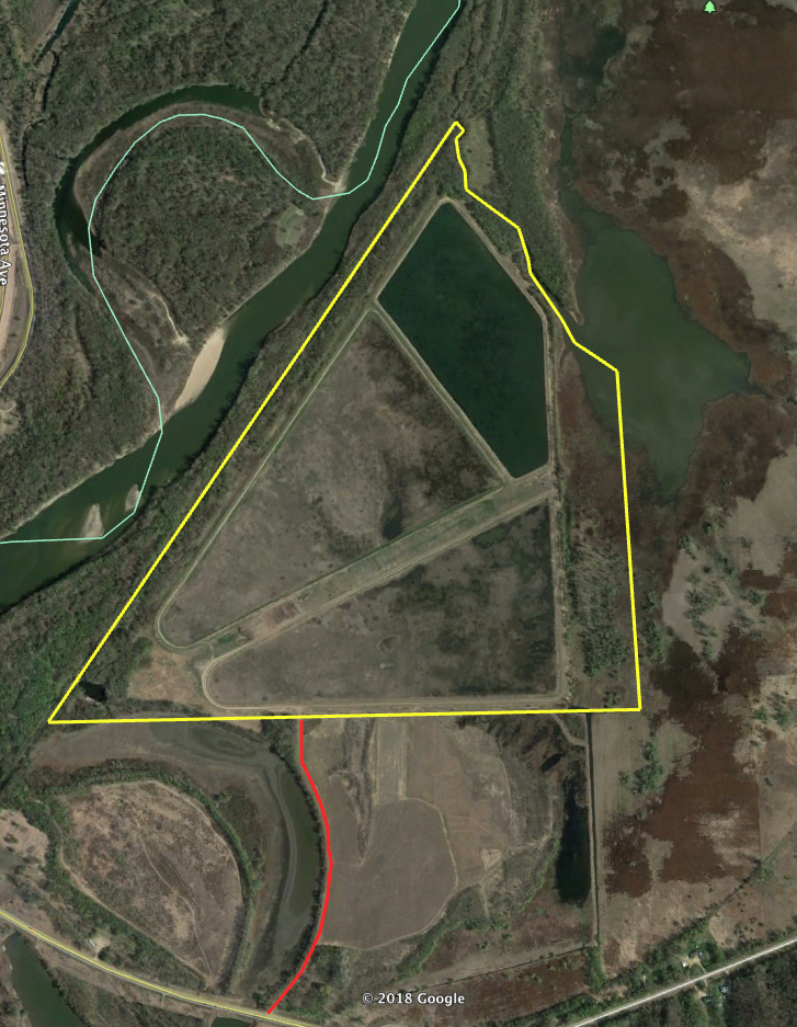
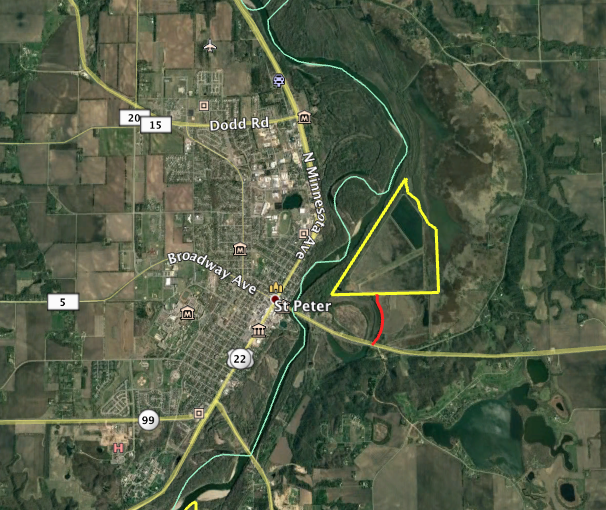
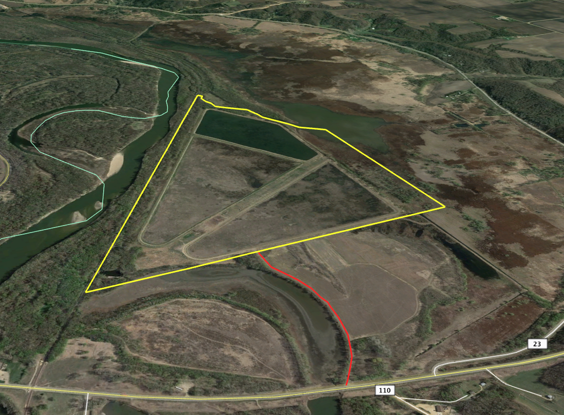
PRICE REDUCED! Mother nature has provided the Minnesota River bottom with some drier weather in 2020. With less water on this property, it has completely changed the habitat dynamic that exists here. For the last couple years, these levee ponds have been open water. This year the water levels have been allowed to drain and new vegetation has emerged. As you will see from the drone video, the ponds in the summer months of 2020 are 50% vegetations making for excellent waterfowl habitat heading into the fall. All three ponds have a natural clay floor with no fabric lining. Thus, allowing you to plant a food source in the spring and summer then flooding them during the fall hunting seasons. The ability to create waterfowl habitat with natural vegetation and or a flooded food source is a proven tactic used by waterfowl hunters throughout the country especially in the southern states. With a holding capacity of four feet in water depth, you would be able to flood multiple types of crops from corn to Japanese millet and everything in between. The ability to grow natural vegetation such as cattails also exists creating the ability to have multiple types of habitat for roosting areas and feeding areas. Locked gated entry to an easement road from State Highway 99 sets the stage as you enter the property overlooking the south pond. The south pond is 60 acres and has the highest elevation. The middle pond is 75 acres and the north pond with the lowest elevation is 44 acres. The top of the levy system has been well maintained with gravel making travel around the levy system very convenient. Within the over 295 deeded acres comes over 55 acres of timber. The levy system is surrounded on two sides by dense Minnesota River Bottom making this an ideal place to hunt both whitetail deer and turkeys. Throughout the levy system and surrounding river bottom, there is an abundance of deer sign. The levy system and surrounding geography make natural pinch points as deer move up and down the Minnesota River. Across the western boundary sits over 600 acres of public land in the Ottawa State Wildlife Management Area. The eastern boundary is less than 500 feet from the shoreline of the Minnesota River. Across Paul’s Creek to the north and past the southern boundary is well managed private land, creating an incredible neighborhood for multiple species of wildlife. Outside of the incredible hunting potential, exists many other opportunities. Historically this property has been an attraction from bird watchers around the state. With little to no management, these ponds have attracted multiple species of waterfowl, songbirds, and shorebirds. These numbers will drastically increase with the right management plan. Furthermore, the water control structures would allow for private fisheries management. In 1960 the City of Saint Peter built these ponds and levies as a waste management system and remodeled them in 1983 to the current condition. In 2004 this property was abandoned as a waste management system and decommissioned by the MPCA. For 14 years this property has set idle and become a waterfowl hunters dream. The property consists of three ponds and a state-of-the-art water control system. The water control system is comprised of multiple water control structures allowing you to move water from the highest elevation pond to the lowest elevation pond eventually draining into Paul’s Creek on the north side of the levy system.
Details
- Three separate ponds with water control capabilities
- The ability to flood crops for waterfowl habitat
- The ability to flood natural vegetation for waterfowl habitat
- Approximately 55 acres of timber
- Multiple water control structures
- Located in a good waterfowl migration flyway
- Gravel path access around the property
- Good easement road access
- Located one mile outside of Saint Peter city limits
- Located one hour from Minneapolis / Saint Paul airport
- Great wildlife neighborhood
Summary
Features
Wild Game, Whitetail, Waterfowl, Turkey, Upland Game, Waterfront, Pond (0-3 acres), Improvements, Investment, Big Game, Small Game, Dove, Other Game, Duck, Geese, Roads, Road Frontage, Highway, Road Access, Gravel, Fence, Partial Fence, Fence Material, Wire, Recreational Improvements, Trail Network, Building Improvements, Gated Entrance, Area Features, Public Hunting, Activities on Property, Hunting, Fishing, Hiking, Boating, ATV Riding, Horseback Riding, Camping, Family Activities, Biking, Snowmobiling, Wild Game, Whitetail, Waterfowl, Turkey, Upland Game, Waterfront, Pond (0-3 acres), Improvements, Investment, Big Game, Small Game, Dove, Other Game, Duck, Geese, Roads, Road Frontage, Highway, Road Access, Gravel, Fence, Partial Fence, Fence Material, Wire, Recreational Improvements, Trail Network, Building Improvements, Gated Entrance, Area Features, Public Hunting, Activities on Property, Hunting, Fishing, Hiking, Boating, ATV Riding, Horseback Riding, Camping, Family Activities, Biking, Snowmobiling
Road Frontage
State Highway
Road Surface
Gravel
Fencing
Partial
Land Details
Pond
Improvements/Features
Big Game, Waterfowl, Upland Game, Small Game, Trail Network, Gated Entrance
Land Type
Hunting and Recreational, Waterfowl
Land and Farm Property Types
Land - Hunting, Land - Recreational
Property Type
Recreational Land, Hunting Land
Other Property Details
Coordinates
44.3311, -93.9343
Annual Taxes
$0
Sold Property
For more information or to see additional properties currently for sale see Bryce McVicker's listings.